Willey History: Sutton-in-Ashfield, Nottinghamshire, UK
The source of much of the information for this page is W. Clay-Dove's book Sutton-in-Ashfield in Times Past, published in 1978 by Countryside Publications Limited. The book is a collection of old photographs, with captions, of Sutton-in-Ashfield. I tried to find an official website for the town but I was unsuccessful. If you know of one, please email me.
Sutton-in-Ashfield is located on the edge of Sherwood Forest approximately 25 km (14 miles) north of Nottingham. It currently has a population of about 40,000. The photo at left shows Outram Street looking towards Portland Square. The photo is taken from what used to be the bridge over the old Northern railway line serving the Sutton train station.
Sutton is an common English placename of Anglo-Saxon origin, the "ton" indicates enclosure or fenced in area. The additional name of Ashfield came from the abundance of Ash trees in Sherwood Forest. Sutton-in-Ashfield appears as Sutone in the Domesday Book, a comprehensive "census" of taxable property in England carried out in 1085 by order of William the Conqueror.
The parish church, St. Mary Magdalene, dates from the 12th century. It is mentioned in Dr. Robert Thoroton's Antiquities of Nottinghamshire published in 1678 that the church was given to the Thurgarton Priory in 1189. The church records date from 1577. Up to 1978 (the date of W. Clay-Dove's book) over 56,000 children had been baptised (including me), 17,000 marriages celebrated and over 22,000 people buried in the churchyard.
The North Notts area is dotted with coalmines and mining was a key industry for towns like Sutton-in-Ashfield. In the 17th century, the textile industry was introduced to the town and Sutton-in-Ashfield rapidly changed from an agricultural village to an industrial town.
In November 1811, three hundred Luddite rioters marched from Nottingham to Sutton-in-Ashfield with the aim of destroying machinery introduced to speed up the stocking manufacturing process. The mob dispersed when soldiers arrived from Mansfield but not before seventy frames were destroyed.
Like most towns in similar situations, Sutton-in-Ashfield's economy suffered with the decline in the mining and textile industries. The development of industrial estates near the M1 motorway have provided some diversity to the economy. The A38 bypass will likely provide opportunities for new industrial estates and train service has returned to the town as a result of the recent construction of the rail line to Nottingham.

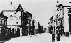
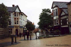
The town centre, particularly around the Portland Square and market area, has been converted to a pedestrian mall. In the middle of the Square the town now boasts what is billed to be the largest sun dial in Europe. The two photos above show a view of Low Street taken from Market Place. The photo at left (Photo from the book - Sutton-in-Ashfield in old picture postcards) was taken around the turn of the century while the photo at right was taken in 1996 when my parents visited Sutton. Notice that many of the buildings in the older photo are still there today.
According to W. Clay-Dove, the Willey family settled in Sutton-in-Ashfield in the early 18th century. William Willey came to the town as a young man around 1750 and married Anne Frignal twelve years later. Many of our ancestors were in the retail meat or fish trade. At left is a photo of the Willey and Son, Fish Merchants premises around 1900 (Photo from the book - Sutton-in-Ashfield in old picture postcards). The block of buildings was torn down in 1905 to expand the market.
My paternal grandmother's family name was Bellamy. My maternal grandfather's family name was Broughton and his wife's maiden name was Bean.
